Water water everywhere ….
In an effort to clarify the issue of where the water we drink comes from I put in an EIR request to United Utilities.
It took them some time to come up with a response but here is a summary.
If you live in the Fylde then your water comes from a variety of sources:
*Franklaw WTW
*Hodder WTW
*Haweswater Aquaduct
*Watchgate WTW
If you live in the FY8 area then your water is sourced as follows

So we can see two things here. A large proportion of the water (34%) does in fact come from boreholes, but they are all east of the Woodsfold fault.
The question of whether contamination of the Sherwood aquifer west of the fault could result in issues in the same aquifer east of the fault is still an open one. As Professor David Smythe suggests
Equally a large part of Cuadrilla’s PEDL 165 is located east of the fault, so whilst any contamination of the aquifer east of the fault from Preston New Road might take some time, contamination of the aquifer from other sites could be much more immediate.
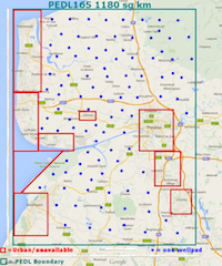
The image below shows a rough visualisation of PEDL 165 and the approximate location of the Woodsfold fault, superimposed onto the Environment Agency’s map of water abstraction points within it.

What is very clear here though is that when the Fracking PR machine tries to claim that we don’t get water from boreholes that could be affected by fracking in PEDL 165, and it all comes from the Lakes, they are lying to us.

Finally, United Utilities claim not to be aware of the presence of a shallow fresh water aquifer at PNR, although the BGS clearly state that it does exist. We find this surprising but perhaps if it is only used for “private drinking water supply, farms and golf course irrigation” then there is no necessary reason why it should be of any interest to United Utilities.
This does not of course mean that it is not valuable or somehow not worth protecting!

We hope that this clarifies some of the questions regarding the sources of our public and private potable and no-potable water.


